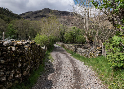
Borrowdale

A few photos I took on one of my regular walks down Borrowdale. Parked at Rosthwaite and then following the Cumbria Way towards Grange. I stopped at the old quarries which is about half way to Grange village and retraced my steps.

Considering Borrowdale was so busy, I saw very few people on this walk. It was the first time I had been down Borrowdale since the lockdown restrictions were eased, and it sure felt good!

Cumbria Way, Rosthwaite

Stepping Stones, River Derwent

River Derwent

River Derwent

River Derwent

High Hows Wood

High Hows Wood

High Hows Wood

High Hows Wood


Moss on tree

High Hows Wood

Slate Quarry Remains

Slate Quarry Remains

Borrowdale

Blossom Tree

High Hows Wood


Wells and Glastonbury

Wells is a medieval city nestling on the southern side of the Mendip Hills with the Somerset Levels stretching away to the south and west. The history of Wells goes right back to Roman times, when we know that there was a settlement, probably because of the springs that bubble up here. It gets its name from these springs which can today be found in the gardens of the Bishop's Palace. 

It is the smallest city in England and can call itself a city because of the famous 13th century Cathedral which, as seems to be the case with lots of historic places these days, was covered in scaffolding, which is why there is a distinct shortage of photos of it in this blog. 

Wells remains remarkably unspoilt and has lots of other historic buildings like the moated Bishop's Palace, Vicars' Close and St Cuthbert's Church. Outside the walls of The Bishop's Palace lies the Market Square and, as we picked a market day to visit, the place was heaving. 

We quickly found refuge in The Bishop's Palace Gardens before making our way to Vicars' Close with its cobblestones and tall chimneys. It is claimed to be the oldest purely residential street with original buildings surviving intact in Europe. It consists of numerous Grade I listed buildings, built in the mid 14th century for Bishop Ralph of Shrewsbury, plus a chapel and library at the north end, and a hall at the south end, over an arched gate. Furthermore, it is connected at its southern end to the cathedral by way of an overhead walkway.

This was the first time since the start of the pandemic that we had both been to a crowded and hectic city, and it quickly tired us out. We were both relieved to get back to the car and travel the few miles to Glastonbury where hopefully we would get a bit of peace and quiet. 

Wow, what a difference Glastonbury was. Its history, myth and legend combine in such a way that most visitors cannot fail to feel the “vibes” and powerful atmosphere of the town. 

Straight out of the car park, and we were treated to some incredible street art and then, heading towards the Market Cross, we were hit by our first whiff of weed which more or less stayed with us throughout our visit! 

The centre of town consists of a main street with a myriad of courtyards and alleyways leading off it. Every shop seems to be a New Age shop, selling incense, candle, crystals, jewellery, clothing etc. Everyone was friendly and no-one had a rush in them. In fact, it felt as though I had been transported back in time to the late 1960s hippy era, with groups of people just sat about chilling and having a 'smoke'. 

Glastonbury is thought to have been a site for pre-Christian worship, perhaps because of its location by the Tor. There is a form of terracing around it which has been interpreted as a maze based on an ancient mystical pattern. If so, it would have been created four or five thousand years ago, around the same as time as Stonehenge. There is also a ruined medieval church at the top of the Tor, the tower of which remains.

Two thousand years ago, at the foot of the Tor was a vast lake called “Ynys-witrin”, the Island of Glass. It is partly from this that the association of Glastonbury with legendary Avalon comes about, as in Celtic folklore Avalon was an isle of enchantment, the meeting place of the dead. Legend has it that King Arthur, along with his wife Guinevere, are buried in the grounds of Glastonbury Abbey, south of the Lady Chapel, between two pillars. The monks of the Abbey, having heard the rumours, decided to excavate the site and unearthed a stone slab, under which was found a lead cross inscribed in Latin, “Hic iacet sepultus inclitus rex arturius in insula avalonia”, “Here lies buried the renowned King Arthur in the Isle of Avalon”. Also found were a few small bones and a scrap of hair. 

The legend of the Holy Grail brings together the myths and legends of King Arthur and the story of Joseph of Arimathea building the first church at Glastonbury. The Glastonbury legend has the boy Jesus and his uncle Joseph of Arimathea building the first wattle and daub church on the site of Glastonbury Cathedral.

After the crucifixion, lore has it that Joseph travelled to Britain with the Holy Grail, the cup used by Christ at the Last Supper and later by Joseph to catch His blood at the crucifixion. Upon arriving on the isle of Avalon, Joseph thrust his staff into the ground. In the morning, his staff had taken root and grown into a strange thorn bush, the sacred Glastonbury Thorn. Joseph is said to have buried the Holy Grail just below the Tor, where a spring, now known as Chalice Well, began to flow, and the water was supposed to bring eternal youth to whoever would drink it.

Bishop's Palace Garden

Bishop's Palace

Bishop's Palace

Bishop's Palace

Bishop's Palace

Wells Cathedral

Wells Cathedral

Bishop's Palace

Vicars' Close

Vicars' Close

Vicars' Close

Vicars' Close

Vicars' Close

Vicars' Close

Bishop's Palace

Vicars' Close

Vicars' Close

Wells

Street Art, Glastonbury

Street Art, Glastonbury

Market Cross

Glastonbury

Glastonbury

Glastonbury

Glastonbury Tor

Glastonbury

Glastonbury

Glastonbury

Glastonbury

Glastonbury

Glastonbury


Lynmouth, The Valley of Rocks and Watersmeet

 I love Lynmouth and Lynton, if it wasn't so busy I think I could spend a holiday there. Lynmouth straddles the confluence of the West Lyn and East Lyn rivers, in a gorge 700 feet below Lynton, which was the only place to expand to once Lynmouth became as built-up as possible. 

 On the 15th and 16th of August 1952, a storm of tropical intensity broke over south-west England, depositing 9.0 inches of rain within 24 hours on the already saturated soil of Exmoor. It is thought that a cold front scooped up a thunderstorm, causing debris-laden floodwaters to cascade down the northern escarpment of the moor, converging upon the village of Lynmouth; in particular, in the upper West Lyn valley, fallen trees and other debris formed a dam, which in due course gave way, sending a huge wave of water and debris down the river. 

Overnight, more than 100 buildings were destroyed or seriously damaged along with 28 of the 31 bridges, and 38 cars were washed out to sea. In total, 34 people died, with a further 420 made homeless. The seawall and Rhenish Tower survived the main flood, but were seriously undermined. The tower collapsed into the river the next day, causing another temporary flood. Similar floods had been recorded at Lynmouth in 1607 and 1796. After the 1952 disaster, Lynmouth was rebuilt, including diverting the river around the village. 

Opposite Lynmouth Harbour is the Flood Memorial Hall. The permanent free exhibition inside includes a scale model of the village pre-flood, along with images of the buildings which were destroyed and how to identify their sites. There are many personal accounts, photos, as well as material on the recent theory that it may have been the result of cloud-seeding experiments by the military.

Today, whilst still pretty and retaining its charm, Lynmouth is a typical resort with many cafés, restaurants and gift shops. The two villages are connected by a funicular cliff railway opened in 1890 which is the highest and the steepest, totally water powered railway in the world and one of only three in England.

We had a nice walk around the village, but again, not a lot was open due to the pandemic. We did manage to find a pub which was serving coffees, so we sat in the beer garden overlooking the harbour and had a cappuccino each. However the village was still fairly busy, so we didn't hang around too long and instead, went off in search of the romantically sounding Valley Of Rocks situated above Lynton. What a fabulously impressive place it turned out to be.

The Valley Of Rocks is thought to have been formed during the Ice Age when the ice sheet prevented the East Lyn River from reaching the sea on its normal route and was diverted westwards. When the ice sheet retreated, the river was able to resume its original path, leaving this valley riverless. Over the years, the valley has silted up to become the U-shape it is now. The right-hand side of the valley is separated from the sea by a series of rocky cliffs, along which The South West Coast Path runs. 

Dodging the showers, we managed to have a quick look around and take some ace photographs of the cliffs but, as time was pressing, we didn't really do the place justice. Hopefully the next time we go, we will stay longer and have a proper walk and explore.

Our last port of call for the day was Watersmeet which was a couple of miles out of Lynmouth and which lies at the bottom of a steep wooded valley where the East Lyn River and Farley Waters meet in a series of waterfalls and cascades. It is one of those places where, whatever superlative you use to describe it, falls well short of the mark. It is without doubt the most beautiful woodland area I have ever visited, and every step we took was a pure joy. We walked up in to Barton Wood which is all native woodland and then back down to Watersmeet House where we sat outside and had a coffee. Come to think of it, I don't recall seeing one evergreen tree in the entire area. I should imagine it is spectacular when all the autumn colours are on show.

Reluctantly, we toiled our way out of the valley and back to the car and then drove back over Exmoor. The road we returned on came out only a stone's throw from Torre Cider farm, but sadly it was closed for the day, so it was back to Watchet. 

A long but incredible day. We had seen the best of all worlds: coastal, woodland and moorland scenery.

Porlock Bay from Exmoor

Bristol Channel from Exmoor

Exmoor Trees

Exmoor

Myrtleberry Cleave, Lynmouth

Windy Hill, Lynmouth

Lynmouth

Rhenish Tower, Lynmouth

Lynmouth

Lynmouth

Valley of Rocks

Valley of Rocks

Valley of Rocks

Valley of Rocks

Waterfall, Watersmeet

Waterfall, Watersmeet

Watersmeet

Watersmeet


Balmacara and Skye

 WE had a mixed week of weather but on the whole we managed to stay dry. The only wet day was our second day when Sal stayed in the cottage ...