Showing posts with label cascade. Show all posts

Glen Etive

I had a free window before the start of my radiotherapy so headed off to the Highlands for a few days. I managed to get a room at The Moorings Hotel at Banavie which is situated right next to Neptune's Staircase on The Caledonian Canal. It's not cheap but I can afford it so why not?

The Staircase raises the canal by 19m (62ft) over a quarter of a mile of continuous masonry and takes around 90 minutes for a boat to travel up or down the locks. It was built by Thomas Telford between 1803 and 1822 and is the longest staircase lock in Scotland. It is a great location to enjoy ‘gongoozling’ the boats as they travel up and down the lock flight! Fortunately my room overlooked the locks so I got a grandstand seat.

I made good progress travelling up so I decided to have a drive down Glen Etive as I hadn't been down there for years. It is a long road, which goes on for some 14 miles, so I limited myself to going just as far as the first, unsightly hydro-electric works. They are under construction at the moment and planning permission has been given for seven in total. I stopped at the first one which was being built across the Allt a Chaorainn and the land surrounding it has been totally decimated. The constructors had made an utter mess of this once beautiful glen.

I took quite a lot of photos of the many cascades and waterfalls in the glen and also of the surrounding hills and woodlands. Due to recent dry weather, I even managed to get to the falls on the River Coupall and take a shot of the classic, much photographer Buachaille Etive Mor which normally would have been a mud bath. The usually glutinous peat was pretty dry albeit a bit spongy.

My drive through Glen Coe was very busy so I didn't stop. The sunny weather had brought all the visitors out and all the car parks looked to be full. I arrived at the hotel about four o'clock unpacked and had a nice cool lager sat outside, just watching the world go by.


River Coupall

Buachaille Etive Mor

Buachaille Etive Mor

River Coupall

River Coupall Falls

River Etive

Glen Etive

River Etive

Glen Etive

Glen Etive

River Etive

River Etive

Glen Etive

River Etive

Glen Etive

Glen Etive

River Etive

Glen Etive


Lynmouth, The Valley of Rocks and Watersmeet

 I love Lynmouth and Lynton, if it wasn't so busy I think I could spend a holiday there. Lynmouth straddles the confluence of the West Lyn and East Lyn rivers, in a gorge 700 feet below Lynton, which was the only place to expand to once Lynmouth became as built-up as possible. 

 On the 15th and 16th of August 1952, a storm of tropical intensity broke over south-west England, depositing 9.0 inches of rain within 24 hours on the already saturated soil of Exmoor. It is thought that a cold front scooped up a thunderstorm, causing debris-laden floodwaters to cascade down the northern escarpment of the moor, converging upon the village of Lynmouth; in particular, in the upper West Lyn valley, fallen trees and other debris formed a dam, which in due course gave way, sending a huge wave of water and debris down the river. 

Overnight, more than 100 buildings were destroyed or seriously damaged along with 28 of the 31 bridges, and 38 cars were washed out to sea. In total, 34 people died, with a further 420 made homeless. The seawall and Rhenish Tower survived the main flood, but were seriously undermined. The tower collapsed into the river the next day, causing another temporary flood. Similar floods had been recorded at Lynmouth in 1607 and 1796. After the 1952 disaster, Lynmouth was rebuilt, including diverting the river around the village. 

Opposite Lynmouth Harbour is the Flood Memorial Hall. The permanent free exhibition inside includes a scale model of the village pre-flood, along with images of the buildings which were destroyed and how to identify their sites. There are many personal accounts, photos, as well as material on the recent theory that it may have been the result of cloud-seeding experiments by the military.

Today, whilst still pretty and retaining its charm, Lynmouth is a typical resort with many cafés, restaurants and gift shops. The two villages are connected by a funicular cliff railway opened in 1890 which is the highest and the steepest, totally water powered railway in the world and one of only three in England.

We had a nice walk around the village, but again, not a lot was open due to the pandemic. We did manage to find a pub which was serving coffees, so we sat in the beer garden overlooking the harbour and had a cappuccino each. However the village was still fairly busy, so we didn't hang around too long and instead, went off in search of the romantically sounding Valley Of Rocks situated above Lynton. What a fabulously impressive place it turned out to be.

The Valley Of Rocks is thought to have been formed during the Ice Age when the ice sheet prevented the East Lyn River from reaching the sea on its normal route and was diverted westwards. When the ice sheet retreated, the river was able to resume its original path, leaving this valley riverless. Over the years, the valley has silted up to become the U-shape it is now. The right-hand side of the valley is separated from the sea by a series of rocky cliffs, along which The South West Coast Path runs. 

Dodging the showers, we managed to have a quick look around and take some ace photographs of the cliffs but, as time was pressing, we didn't really do the place justice. Hopefully the next time we go, we will stay longer and have a proper walk and explore.

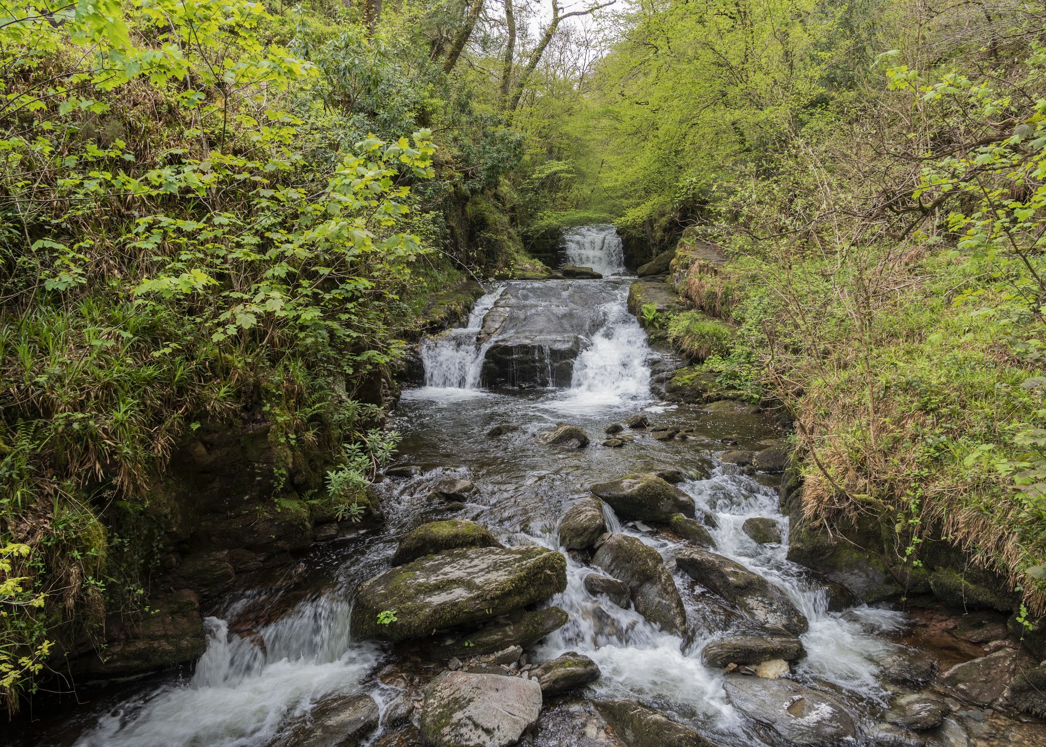
Our last port of call for the day was Watersmeet which was a couple of miles out of Lynmouth and which lies at the bottom of a steep wooded valley where the East Lyn River and Farley Waters meet in a series of waterfalls and cascades. It is one of those places where, whatever superlative you use to describe it, falls well short of the mark. It is without doubt the most beautiful woodland area I have ever visited, and every step we took was a pure joy. We walked up in to Barton Wood which is all native woodland and then back down to Watersmeet House where we sat outside and had a coffee. Come to think of it, I don't recall seeing one evergreen tree in the entire area. I should imagine it is spectacular when all the autumn colours are on show.

Reluctantly, we toiled our way out of the valley and back to the car and then drove back over Exmoor. The road we returned on came out only a stone's throw from Torre Cider farm, but sadly it was closed for the day, so it was back to Watchet. 

A long but incredible day. We had seen the best of all worlds: coastal, woodland and moorland scenery.

Porlock Bay from Exmoor

Bristol Channel from Exmoor

Exmoor Trees

Exmoor

Myrtleberry Cleave, Lynmouth

Windy Hill, Lynmouth

Lynmouth

Rhenish Tower, Lynmouth

Lynmouth

Lynmouth

Valley of Rocks

Valley of Rocks

Valley of Rocks

Valley of Rocks

Waterfall, Watersmeet

Waterfall, Watersmeet

Watersmeet

Watersmeet


Ogden Water Country Park

I hadn't been to Ogden water for a couple of years so thought I would pay it a visit and try out my new 85 mm lens. I arrived quite early so managed to get a parking spot by the roadside. 

I didn't really get any decent photo opportunities until I got into Odgen Clough with its many small cascades, mossy rocks and fallen trees. Unfortunately the deeper I got in to the Clough, the icier it got which eventually forced me to turn back as the last thing I wanted was to have a fall whilst holding the camara.

I was quite pleased with the way it performed, mainly because it let me take handheld close up slow shutter speed shots. I found that I could easily use a shutter speed of one eighth of a second which gave good enough water motion without it being overexposed. 

The next time I use it, I will try it out taking close-up shots, I believe its minimum focusing distance is two feet six inches, which should be ideal for flower photography. For anything closer, I still have a 60 mm macro lens. 

I was surprised how good the paths were as many of my local paths (plus the paths at St Ives) are very muddy due to the weather and increased footfall. I did leave the main path and walk up in to the woods, partly to get away from the crowds but mainly for variety because I find the path around the reservoir rather flat and boring whereas the woodland path has many ups and downs. 

By the time I got back to the car, it was getting very busy, so I think I picked the right time of day to visit. All shots below are taken with that lens.

Woodland Walk

Moss on wall

Woodland Walk

Woodland Walk

Ogden Clough

Ogden Clough

Woodland Walk

Ogden Clough

Ogden Clough

Ogden Clough

Woodland Walk

Ogden Clough

Ogden Clough

Ogden Clough

Ogden Clough

Woodland Walk

Woodland Walk

Woodland Walk

Weir, Ogden Water

Woodland Walk


Autumn Arrives Early

Photos taken locally of the start to the changing of the season on Harden Moor above Keighley in West Yorkshire. The parking and entrance t...